In our 2014 report The Future of Downtown San Jose, we suggested that the city can bring much-needed people and activity downtown by providing better wayfinding to help people navigate downtown and understand all it has to offer. Wayfinding tools can help enhance public spaces and create memorable routes with signs, art, maps and streetscaping. In addition to connecting people to places and spaces, wayfinding tools can help make transit easier to use. And as we discuss in our report Seamless Transit, a high-quality wayfinding system, as part of an overall vision for mobility and access, can support the billions of dollars of investment in the South Bay’s transit network.
The city has taken big steps to implement these recommendations. Since the spring, San Jose’s Office of Economic Development has been working with City ID, with support from the Knight Foundation, to lay the groundwork for a permanent wayfinding program downtown. In June, City ID held a series of walk audits and public workshops that focused on community input and user needs. Two weeks ago, they were back at SPUR’s San Jose office to share what they’ve been working on. Here’s a preview of where they’re headed.
Use a Whole-Journey Approach
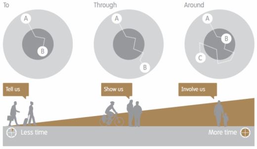
The team recommended design interventions for every stage of a person’s journey: exploring a route on their home computer, transferring to a bus or a train, walking to their destination and so on. This “whole journey” approach to wayfinding is based on the idea that people need the right information, at the right time, in the right place, in the appropriate format and technology.

Different users need different information to complete their journey. Courtesy Centro and CityID, 2014. Interconnect: Improving the Journey Experience.
Each user group also has different information needs, which the system should reflect. The information should be delivered in simple, recognizable, easy-to-read maps of downtown and its connecting transportation networks. This includes integrated journey-planning mobile applications, signs that mirror the direction the user is facing and provide walk times between areas and destinations, and maps that convey not only where transit services go but also how often they run.
Focus on Identity and Shared Experience
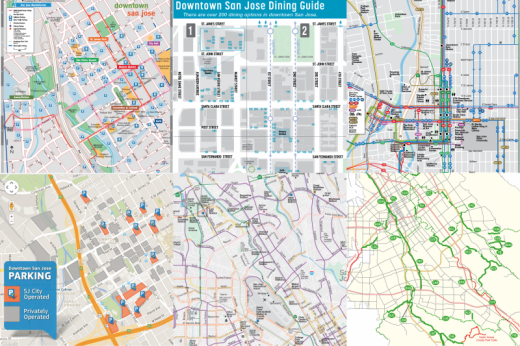
Downtown San Jose is a diverse place, and the city would like to tell that story with one voice. But today, there are a lot of competing voices saying many different things. By reviewing the city’s online presence and key documents like Envision 2040, the city’s general plan, City ID found nearly 20 different maps of downtown San Jose, all geared toward different users or activities. They also recorded 15 different types of wayfinding within the downtown area.

A selection of the many different map styles currently in use in downtown San Jose.
Images compiled by City ID.
Top, left to right: San Jose Redevelopment Authority’s Downtown Walking Map; San Jose Downtown Association’s Dining Guide; and VTA's transit map.
Bottom, left to right: San Jose Downtown Association's ParkSJ map; San Jose Department of Transportation's Bikeways Map; and San Jose Parks, Recreation and Neighborhood Services' Citywide Trail Map.
But it doesn’t have to be this way. The system that City ID will propose aims to visually connect the city in a way that promotes a shared sense of identity and place. Mobile applications, kiosks, signs and maps will work together to reveal and strengthen a recognizable and authentic identity for downtown San Jose that will continue to evolve over time.
Next Steps
In the coming months, City ID will further develop the information and visual products that will make up a holistic wayfinding system for downtown San Jose. When it takes shape, downtown’s assets and attractions will become highly visible. But San Jose can’t do it alone.
Funding for the implementation of wayfinding is fragmented and requires careful planning. For example, the Santa Clara Valley Transportation Authority (VTA) has its own service map, as does Caltrain — and there are no regional standards for transit maps. To compound these challenges, transit agencies receive limited and sporadic funding for marketing materials. For a seamless journey, City ID’s ideas will need to be adopted by a number of partners, including the City of San Jose, VTA, the Metropolitan Transportation Commission and other transit operators in San Jose. Based on the design workshops held at SPUR’s San Jose office two weeks ago, it seems that City ID’s recommendations for greater transportation harmony have been well received by potential partners and there is broad support for working together to improve the experience of San Jose. The design team will be back in November to present further recommendations on program development.