

Photo by Karl Nielsen
The Resilient by Design Bay Area Challenge is an innovative year-long collaborative design challenge that brought together local residents, public officials and a broad range of experts to develop innovative design ideas to strengthen the Bay Area’s resilience to sea level rise, severe storms, earthquakes and flooding.
SPUR has long been a supporter of Resilient by Design, and has been involved from the initiative’s earliest days. Inspired by the Rebuild by Design initiative in New York after Hurricane Sandy, we all believed that the Bay Area could respond to a call for resilient design ideas that could be implemented before a disaster. SPUR has worked on sea level rise adaptation and disaster planning for more than a decade, and we have published major reports on earthquake preparation and rebuilding, and climate change adaptation, in addition to the award-winning Ocean Beach Master Plan and Mission Creek Sea Level Rise Study. Because of the relevance to our mission and its potential to make the Bay Area safer and stronger, SPUR staff and board members served on the Executive Board and Research Advisory Group for the RBD Challenge, and many board members and business members of SPUR also worked on design teams.
In the following pages, we share the final design concepts from Resilient by Design. Each is meant to inspire, catalyze action and push us all along the path to a more resilient future. The potential of these designs is apparent; their success is up to us.
Throughout the year-long challenge, nine design teams composed of landscape architects, engineers, designers and other experts worked alongside community members and local governments to identify critical areas along the San Francisco bayfront and propose exciting new solutions to strengthen our region’s resilience to sea level rise, severe storms, flooding and earthquakes.
Regional agencies including the Metropolitan Transportation Commission, Bay Area Air Quality Management District, San Francisco Bay Conservation and Development Commission and the Restoration Authority are taking on next steps from the ideas generated by the Challenge. Working groups continue the collaborative efforts toward building resilience in their communities. Community-based organizations.
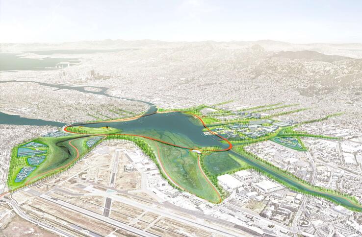
Team: The All Bay Collective
Location: San Leandro Bay; Cities of Oakland, Alameda and San Leandro; Alameda County
Juror Recognition: Recognized for finding a way to bring culture, institutions and the environment forward by design.
Firms Involved: AECOM with CMG Landscape Architecture, UC Berkeley College of Environmental Design, California College of the Arts, Silverstrum Climate Associates, Skeo, Moll de Monchaux, David Baker Architects
The All Bay Collective (ABC) is rethinking the waterways around the San Leandro Bay Estuary to create shared prosperity and proactively protect against the dual threat of sea level rise and groundwater flooding. This design enables existing residents to adapt in place and helps to remedy longstanding social and environmental injustices. Taken as a whole, the Estuary Commons aims to catalyze resilience in local communities, adapts the estuarine environment to produce a shared working landscape, stitches neighborhoods to shoreline by creating green connections, and sets the stage for existing residents to prosper in place while creating space for new homes and jobs.
ABC worked closely with eight community- based organizations from East Oakland to move neighborhood priorities from the margins to the center of the design process. What emerged was a design that locates creeks over highways instead of under them; puts community in the foreground, not the background; and allows natural systems inform and shape infrastructure planning.
ABC’s design calls for several innovative long-term scenarios. Its Tidal Cities concept envisions dynamic shoreline landscapes that combine tidal ponds with floating mixed-use neighborhoods to create floodable urban fabric. The Coliseum Station Multi-Modal Transit Hub integrates BART, Amtrak, AC Transit, and the Oakland Airport air train under one roof, forming one end of a new BART-to-shoreline civic spine. And Resilient Equity Hubs inspire common stewardship and deliver shared local benefits.
resilientbayarea.org/san-leandro-bay/
Team:BIG + ONE + Sherwood
Location: Islais Creek; City and County of San Francisco
Juror Recognition: Recognized for seeing both the opportunities and the risks of impending changes in Islais Creek and for its sensitivity to the environment and the place.
Firms Involved: Bjarke Ingels Group (BIG), One Architecture & Urbanism (ONE), Sherwood Design Engineers (SDE), Moffatt & Nichol, Nelson Nygaard, Strategic Economics, The Dutra Group
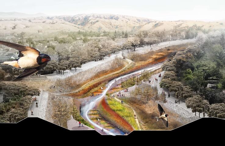
Islais Hyper-Creek is a vision for the area where ecology and industry coexist. A large park with a restored tidal creek system and soft shoreline shares the area with maritime functions, light manufacturing and logistics that have formed the area’s economic backbone for decades. This park plays an important role in building physical and social resilience: it retains, conveys and cleans water, protecting the surrounding neighborhoods while providing benefits to the community. The real innovation of Islais Hyper-Creek is rooted in its renewed attitude toward the area’s dual history of vibrant ecology and industry, categories often at odds with one another.
The mouth of San Francisco’s largest historic watershed—Islais Creek and its wetlands—was capped with rubble from the 1906 earthquake, and currently faces mounting risks of liquefaction, sea level rise and stormwater flooding. The central element of Islais Hyper-Creek is a naturalized creek, its restored watershed absorbing millions of gallons of stormwater annually while providing multilevel ecosystem benefits. Public spaces along the swimmable riparian corridor will offer recreational amenities, reconnecting the area to its historic waterfront.
Beyond the creek itself, Islais Hyper- Creek is a holistic district-wide plan. Existing industrial operations in the nearby districts will be consolidated and intensified, creating a vital job and logistics hub dependent on the industrial economy. Infrastructure will be strengthened and adapted to be both floodand earthquake-resistant.
resilientbayarea.org/islais-creek/
Team: Bionic Team
Location: San Rafael;Marin County
Juror Recognition: Recognized for drawing attention to immediate flood risk and for its impressive community engagement effort.
Firms Involved: Bionic Landscape, PennDesign, WXY, Studio for Urban Projects, Enterprise, Michael Yarne, S.F. State’s Romberg Tiburon Campus, Keyser Marston Associates, WRA, RAD Urban, Moffatt & Nichol
“Elevate San Rafael” offers a new paradigm for responding to complex environmental change and does simply, what needs to be done, namely occupying higher elevations and raising the quality of life for everyone. Elevate San Rafael changes the city by combining time-tested approaches to coastal adaptation with a moral, financial, and infrastructural agenda for large-scale adaptation. Redefining the relationship to the bay leverages this singular opportunity to elevate all aspects of life, from community bonds and dignity to socioeconomic standing to change-minded urban policy. It aspires to lift infrastructure to new elevations and purposes, and allow for ecology to persist and expand.
Elevate San Rafael is a two-part proposal addressing near-term needs directly as well as a long-term strategy for large-scale resilience. The proposal frames necessary policy and finance mechanisms to equitably stimulate and guide change. Pilot and catalyst projects protect San Rafael now, enhance community resilience, test new ecological technologies, and buy time to prepare for the future. The long-term strategy engages the forces of development, economy and the environment to reposition the urban form of San Rafael to anticipate change, enhance mobility, reinvent infrastructure, enable ecology—all with a goal of providing enduring protection for another century or more. Like any other regional infrastructure, it will take generations to plan, fund, and build resilience for this nexus of the region.
resilientbayarea.org/san-rafael/
Team: Common Ground
Location: San Pablo Baylands; Solano, Sonoma and Napa Counties
Juror Recognition: Recognized for the greatest ecological potential and sensitive perspective of the interactions among nature, infrastructure and people.
Firms Involved: TLS Landscape Architecture, Exploratorium, Michael Maltzan Arch, Sitelab Urban Studio, Rana Creek Design, Richard Hindle-UC Berkeley, HR&A Advisors, Guy Nordenson & Associates, Lotus Water, Fehr & Peers Transportation
The Grand Bayway considers a new future for Highway 37 as an elevated scenic byway, creating an iconic “front door” to a vast ecological open space previously known to few. Accessible to cyclists, runners, kayakers, campers and fishermen, the Grand Bayway will become a “Central Park” with more 21stcentury sensibilities for rapidly expanding North Bay communities.
The project proposes to resolve the transportation problem of Highway 37 by designing a scenic causeway elevated on columns 20 feet high, allowing tidal flows and marsh migration to return to a natural condition. These same principles operate whether in the current southern alignment or moved to an alternative northern alignment, skirting the edge of stable uplands. The causeway is designed with the same ambition and flair as other iconic bay crossings but based on 21st-century sensibilities for the natural environment and diverse transit types, not just vehicles. Rather than broad concrete platforms on a forest of columns, this design is based on the principles of scenic byway design, curving to open views over the bay and marshes, and oriented to natural landmarks. This level of investment in design and visibility for an ecological “Central Park” will return major value for the region, its identity and its future.
resilientbayarea.org/san-pablo-bay/
Team: The Field Operations Team
Location: South Bay; San Mateo and Santa Clara Counties
Juror Recognition: Recognized for taking a complicated issue that spans geography, jurisdiction and generations, and translating it with a playful and powerful metaphor of a South Bay sponge.
Firms Involved: James Corner Field Operations, Moffatt & Nichol, Magnusson Klemencic Associates, SF BAY National Estuarine Research Reserve, Romberg-Tiburon Center, Andrea Baker Consulting, James Lima Planning + Development, The Bay Institute, SeArc/ ECOncrete, HT Harvey and Associates, Playhou.se, Adventure Pictures
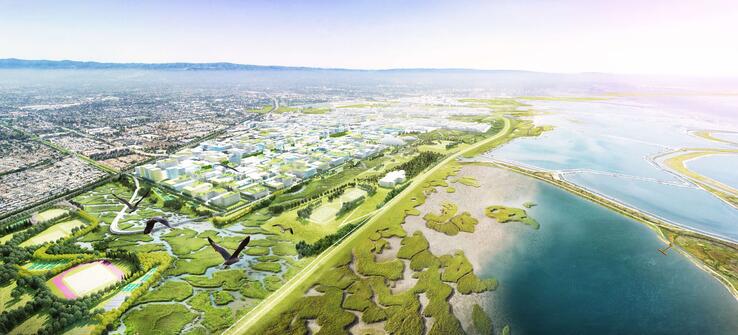
The South Bay Sponge is a design framework for adaptation — for adapting our shoreline and infrastructure and for advancing our methods of planning, design and cooperation to achieve new and resilient forms of settlement on the Bay. The project covers more than 20 miles of shoreline, stretching from Menlo Park to Santa Clara, and is a multijurisdictional vision: it encompasses two counties, one water district, six cities and several federal agencies. These entities all worked closely with the communities in the South Bay and Silicon Valley to shape a dynamic framework for adaptation in the face of climate change and sea level rise, envisioning a future where nature and technology work together to improve the resiliency of our cities and towns.
The ‘Sponge’ is green infrastructure on a largescale: new absorptive landscapes for collecting, filtering and dispersing floodwater during storm events. It is a concept for using nature and natural systems as a primary tool for climate adaptation and resilience in the South Bay, inspired by both the historic function of the region’s intertidal marshlands as flood protection, as well as by remarkable efforts to restore the South Bay Salt Ponds. The potential of a large-scale assemblage of remnant marshlands, newly restored salt ponds and newly constructed wetlands as the core component of a regional flood protection strategy is at once radically innovative and also resonant with today’s South Bay landscape. The South Bay Sponge can also give the landscapes of the South Bay a powerful and legible identity.
resilientbayarea.org/south-bay-towns/
Team: HASSELL+
Location: South San Francisco; San Mateo County
Juror Recognition: Recognized for its pragmatic and convincing focus on neighborhood-level interventions from the mountain to the bay.
Firms Involved: HASSELL, Deltares, Lotus Water, Idyllist, Civic Edge Consulting, Goudappel, Page & Turnbull, HATCH, Brown & Caldwell
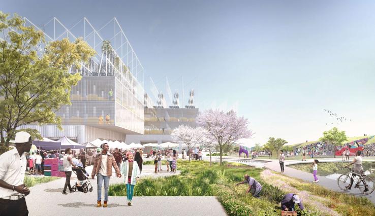
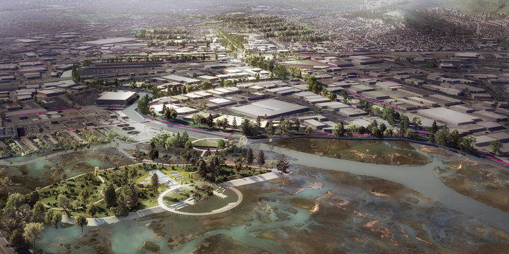
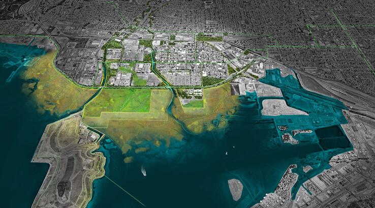
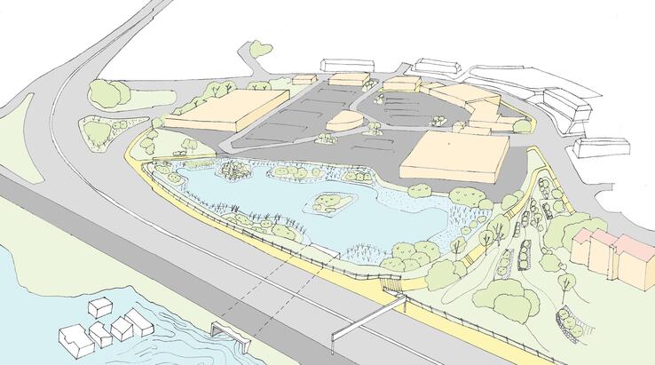
Collect & Connect—Resilient South City is a proposal to create more public space and access along South San Francisco’s Colma Creek, aiming to reduce the impacts of flooding, mitigate against sea level rise, restore native flora and fauna, and connect a continuous green corridor from Orange Memorial Park to a new public park at the shoreline.
The project identifies opportunity sites across the entire Colma Creek watershed to create a resilient network of green spaces, playgrounds, schools and slow streets. A widened creek canal will reduce the impact of recurrent flooding, and restoration of native plants on San Bruno Mountain and throughout the watershed will build biodiversity and reduce irrigation needs. Orange Park is reimagined as a sports and community hub. The new South City Circle Bridge is a pathway for continuous walking and cycling, and a bold statement of prioritized community access to the bay, acting as a gateway to South City for all transport modes. Below this, a native plants nursery will enable flood detention and treat runoff from Highway 101, slowing and improving the quality of water flowing into Colma Creek and the Bay. A new recharge reservoir at the base of San Bruno Mountain will collect stormwater runoff and create passive infiltration through the location’s unique geology.
The HASSELL+ team drew heavily on local voices and insights, creating a temporary community hub on Grand Avenue and hosting conversations with elected officials, community leaders, local residents and students.
resilientbayarea.org/south-san-francisco/
Team: The Home Team
Location: North Richmond; Contra Costa County
Juror Recognition: Recognized for addressing disinvestment and environmental injustice and for advancing the argument for modestly scaled but potentially highly resonant interventions.
Firms Involved: Mithun, Chinatown Community Development Center, ISEEED/Streetwyze, BioHabitats, Integral Group, HR&A Advisors, Moffatt & Nichol, ALTA Planning and Design, Urban Biofilter, Resilient Design Institute
ouR-HOME’s design approach focuses on a regional opportunity: to use investments in infrastructure to leverage health and wealth benefits for disinvested communities. In North Richmond, investments include pump replacement and sea level rise protection for a wastewater facility, major arterial and drowning marshlands. The marshlands provide critical habitat and support the largest eelgrass bed and oyster beds in the bay.
Building on the North Richmond Shoreline Vision Plan, local expertise in the community has shaped a suite of four projects to make direct interventions with profound impacts in the community. These projects include THRIVE, which explores small lot housing splits and community land trusts to support paths to home ownership; FILTER, an urban forest plan that involves planting trees for air and water filtering; GROW, an integrated water plan that uses a range of levee edge typologies that change over time to protect Richmond Parkway, the wastewater facility and the neighborhood; and RELATE, which connects Wildcat Creek Trail to the Bay Trail with an overpass to provide shoreline access. The creation of a green benefits district ties local hiring and improvement back to “returns to the community” rather than a “return to capital”— turning the traditional development model into a multiple benefits model.
resilientbayarea.org/north-richmond/
Team: The Permaculture and Social Equity Team
Location: Marin City, Marin County
Juror Recognition: Recognized for its impact in community capacity building, realigning power distribution and increasing ownership by people directly impacted by design decisions.
Firms Involved: Pandora Thomas, Urban Permaculture Institute, Ross Martin Design, Yale School of Architecture
Rather than only site-specific, element and component-based designs, the Permaculture and Social Equity Team (P-SET) proposed an unconventional approach—a social design process that builds community capacity and ecoliteracy to address the challenges of coastal adaptation and resilience planning, especially in vulnerable communities experiencing generations of marginalization and exclusion. The team was invited to implement their process in Marin City by Shore Up Marin, an environmental justice and resiliency planning organization.
Through an eight-week course, the community enhanced its existing advocacy practices and literacy to more effectively engage with municipal, regulatory and regional stakeholders. The opportunity was to transform the process of ‘engagement’ to one of authentic partnership—to initiate site design by first increasing the capacity of the resident community by recognizing, leveraging and enhancing the already existing assets and initiatives in a place. This reparative approach intends to redress the structural inequities and result in a comprehensive, living People’s Plan to become a more effective starting point for the complex process of our collective adaptation to living in an uncertain climate.
resilientbayarea.org/marincity
Team: Public Sediment
Location: Alameda Creek; Fremont, Union City and Newark; Alameda County
Juror Recognition: Recognized for highlighting the power of sediment and the creek and the power of scale.
Firms Involved: SCAPE Landscape Architecture with Arcadis, the Dredge Research Collaborative, TS Studio, the UC Davis Department of Human Ecology and Design, Cy Keener, and the Architectural Ecologies Lab
Public Sediment for Alameda Creek is an implementable project that links Alameda Creek with its historic baylands. It provides a sustainable supply of sediment to bay marshes and mudflats for sea level rise adaptation, reconnects migratory fish with their historic spawning grounds and introduces a network of community spaces that reclaim the creek as a place for people.
The bay’s marshes and mudflats are multibenefit resources. They provide habitat, cushion the urban edges of Alameda County from extreme storms and tidal events, filter water and sequester carbon. Yet these resources are at risk: land subsidence and sea level rise threaten to damage or destroy the bay’s marshes and mudflats by 2100. Projections show that with 3.5 feet of sea level rise by 2100, the region’s current sediment supply will not sustain these ecosystems over time. The San Francisco baylands potentially face a large-scale transformation from marsh to open water, exposing communities to more intense flooding from the bay. This risk is invisible to the general public yet increases year by year.
Public Sentiment proposes to reintroduce sustainable sediment flows, ecological connectivity, and public access back to the creek to address the climate change threats of the future.
resilientbayarea.org/alameda-creek/
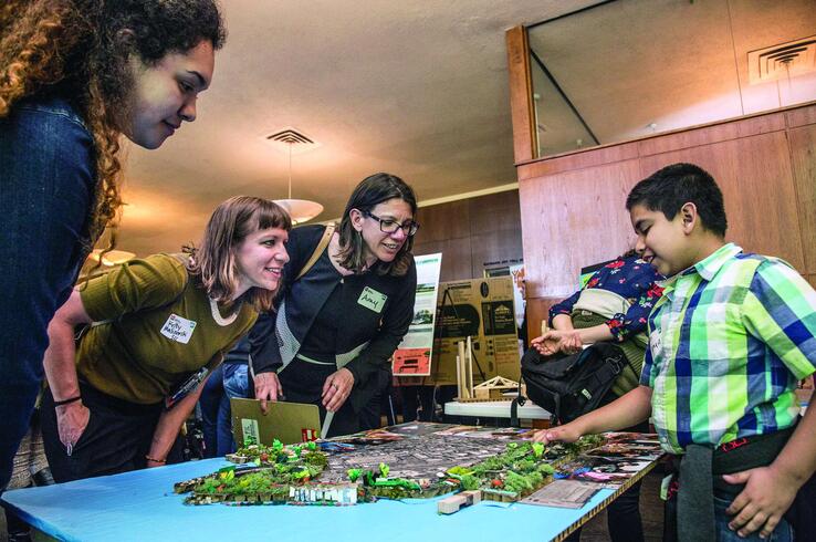
Hundreds of Bay Area students, ages 8 to 18, brought big ideas and unbounded energy to the Bay Area’s first-ever Y-PLAN Resilient by Design Youth Challenge. Y-PLAN is an award-winning civic learning and engagement strategy based at the University of California Berkeley Center for Cities + Schools. Its Resilient by Design Youth Challenge was a unique opportunity to engage over 800 young people, community members, civic leaders, parents and local schools in reimagining and redesigning communities most vulnerable to climate change and sea level rise. The Challenge also prepared K-12 teachers to engage students in these issues in partnership with local leaders and RBD professional teams.
The young participants demonstrated the important role they can play in their communities’ efforts to effectively respond to inevitable challenges like rising seas, flooding, earthquakes and man-made disasters while confronting daily stresses like food insecurity and homelessness. In all, 830 students from 32 schools in 10 disadvantaged communities from Oakland to San Rafael to East Palo Alto were involved in this exercise of planning, learning and acting.
Proposals included floating homes, electric buses rerouted to reach all communities, and educational boardwalks installed above newly appearing marshes; exercise bikes powering a gym; and a college-bound culture with food, housing and educational opportunities available to everyone. In Richmond, three high schools developed a comprehensive Resilient Richmond Plan that included an environmentally friendly development at Point Molate, with affordable housing and access to healthy food.